

WHEN THE MOUNTAIN BROKE
The 26 August 2026 Rasuwa–Bhote Koshi Disaster: Cryospheric Risk, Resilient Infrastructure and Climate Justice in the Himalaya.
The catastrophe that descended from Langtang was more than a flash flood. It exposed a new generation of Himalayan risk, one in which glaciers, unstable rock, rivers, hydropower, highways and settlements can become connected elements of a single cascading disaster. Nepal must now rethink how it monitors its mountains, designs its infrastructure and argues for climate justice.
By Dr. Dinesh Kumar Shrestha

On the morning of 26 August 2026, the mountain itself became part of the flood.
At approximately 8:37 a.m. Nepal time, a massive rock-and-ice collapse occurred high on the glaciated flank of the Langtang Lirung massif (Picture 1). What began thousands of metres above inhabited valleys rapidly transformed into a cascading mixture of ice, rock, water, mud and sediment. It descended into the Lhende Khola system and propagated through the Bhote Koshi and Trishuli river corridors with devastating consequences. Emerging scientific reconstruction places the source failure at around 5,200 metres above sea level and shows how quickly the event developed, on a timescale measured not in hours, but in minutes.
This was not an ordinary monsoon flood.
It was not simply a river receiving too much rainfall.
It was a high-mountain cascading disaster in which the failure of part of a mountain was transmitted through a river system into settlements, roads, bridges, hydropower installations and national economic infrastructure far downstream.

Picture 1: Rock–ice collapse source area on the Langtang Lirung massif, Rasuwa, Nepal (Source: Google Earth Pro)
Picture 2: Rock-ice collapse Flash Flood Affected area in Rasuwa (Source: Nomad Lawyer, 27 August 2026)
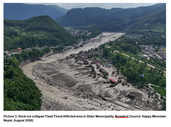
Picture 3: Rock-ice collapse Flash Flood Affected area in Bidur Municipality, Nuwakot (Source: Happy Mountain Nepal, August 2026)

By mid-September, search, rescue and recovery operations were still under way. Government updates described enormous loss of life, widespread displacement and extensive damage to houses, public buildings, bridges, roads, hydropower facilities and other critical infrastructure. The disaster affected communities from Rasuwa downstream through Nuwakot and Dhading and beyond.
The tragedy demands humanitarian response and reconstruction.
But it demands something more.
It requires Nepal, and indeed every high-mountain country, to reconsider what constitutes a credible disaster scenario in a rapidly changing cryosphere. The cryosphere comprises the frozen components of the Earth system, including glaciers, snow cover, ice and permafrost, all of which play a critical role in Himalayan water resources and natural hazards.
A Disaster that Began above the Conventional Design Horizon
For generations, Nepal’s engineers have designed bridges, roads, hydropower plants and river-training works against floods derived principally from hydrological records.
We estimate rainfall.
We calculate runoff.
We undertake frequency analysis.
We determine a design discharge corresponding to a particular return period.
We establish water levels, velocities, scour depths and freeboards.
That methodology remains indispensable. But Rasuwa demonstrated its limitations when the initiating event is not rainfall alone.
A large rock–ice avalanche introduces an entirely different combination of processes.
A collapsing mass may descend several kilometres vertically, converting enormous gravitational potential energy into kinetic energy. It may fragment on impact, melt part of its ice through friction and impact heating, entrain water and sediment, block a river, generate a temporary natural dam, displace stored water, or produce a debris-rich surge. Downstream, the evolving flow may scour riverbeds, erode banks, collect additional boulders and sediment and destroy structures that could safely withstand an ordinary water flood.
Preliminary modelling of the 26 August event illustrates the scale involved. One recent preprint explores a source release of about 35 million cubic metres and reproduces the exceptionally rapid arrival of the flow at locations near the border. The research remains preliminary and has not yet completed peer review, but it reinforces an essential engineering conclusion: this was a mass-movement-to-river cascade, not simply an extreme discharge generated by rainfall.
The distinction is critical.
A bridge designed for a conventional flood may fail when struck by large boulders and debris.
A hydropower intake designed for sediment-laden monsoon water may be overwhelmed by a mass flow containing unprecedented sediment concentrations.
A riverbank settlement that is above the statistical flood level may still lie within the runout zone of an avalanche-induced surge.
A road may survive rainfall-induced flooding but fail when the river suddenly shifts laterally after its bed is raised by metres of deposited debris.
The engineering question emerging from Rasuwa is therefore profound:
What happens when the design flood no longer consists mainly of water, when part of the mountain itself enters the river?
Future Himalayan infrastructure assessments must answer that question.
The Tyranny of Minutes
Perhaps the most frightening feature of the Rasuwa disaster was its speed.
One emerging scientific reconstruction estimates that the avalanche-derived flow travelled approximately 22 kilometres within six to seven minutes in its upper reaches. Another study analysing flood-warning latency found that the first monitored downstream location was reached roughly 13 minutes after the initial failure, while the mass public warning came substantially later. Both studies are preliminary, but together they illustrate the fundamental problem confronting Himalayan early-warning systems.
By the time a conventional downstream river gauge confirms an extreme flood, the most vulnerable upstream settlements may already have been struck.
This changes the philosophy of early warning.
For normal floods, we often monitor the river.
For cascading cryospheric disasters, we must also monitor the mountain.
The warning chain must begin before the flood has fully formed.
That means observing glacier margins, unstable rock faces, glacial lakes, permafrost zones and slopes capable of falling into river valleys.
The goal is not to claim that every collapse can be precisely predicted. It cannot.
Indeed, emerging satellite analysis of the Langtang Lirung failure reports that no clear precursor could be confidently detected in the particular Sentinel-1 radar backscatter record examined before the collapse. That is an important scientific warning against promising technology more than it can deliver.
But inability to predict every failure does not justify blindness.
A modern Himalayan warning system should integrate different layers of observation so that when any abnormal signal appears, it can be rapidly cross-checked.
This leads to a concept Nepal should consider urgently:
A National Himalayan Cryosphere Hazard Surveillance System
Such a system could combine:
satellite photography and cloud-penetrating radar imagery; high-resolution three-dimensional mapping of mountain terrain; satellite techniques capable of detecting subtle slope movement; automatic mountain weather stations; precision GPS-type GNSS instruments to measure glacier and slope movement; sensors monitoring glacial-lake and river levels; instruments capable of detecting the ground vibrations and low-frequency sound produced by major avalanches; ground-based radar watching selected unstable slopes; high-altitude drone surveys; and artificial intelligence that compares repeated observations and alerts specialists to unusual changes.
The objective would be neither to watch every square metre of the Himalaya continuously nor to promise perfect prediction.
It would be to identify priority source zones, beginning with periodically updated inventories of potentially dangerous glacial lakes and unstable high-mountain slopes; detect unusual changes rapidly; and connect detection directly to emergency action.
Nature’s recent editorial on the Rasuwa event makes essentially this point: science may not be capable of forecasting every individual mountain collapse, but it can connect source monitoring, event detection, impact forecasting, warnings and pre-authorised response into a chain capable of outrunning at least part of the hazard.
That distinction matters.
The success of an early-warning system should not be measured by whether it can stop the mountain from moving.
It should be measured by whether it can move people before the mountain reaches them.
From Military Drones to Mountain Guardians
The catastrophe also invites a broader technological question.
Humanity has developed astonishingly sophisticated unmanned systems for warfare. Drones can travel long distances, navigate hostile terrain, operate beyond the direct line of sight, carry sophisticated sensors and transmit information in real time.
Why should comparable ingenuity not be mobilised to protect vulnerable mountain communities?
High-altitude drones could inspect unstable glacier margins after abnormal warming periods. They could map cracks and recently exposed rock. They could acquire thermal, optical and multispectral imagery, deploy lightweight sensors at otherwise inaccessible locations, inspect newly formed glacial lakes, monitor temporary natural dams and establish emergency communication relays when terrestrial networks have failed.
Artificial intelligence could be used to compare repeated imagery and flag changes requiring expert review.
A constellation of relatively inexpensive sensors could provide far more continuous information than occasional field expeditions alone.
The original temptation might be to go even further, to imagine drones physically deploying steel fences or barriers capable of arresting moving glacier masses.
The instinct behind such an idea is valuable: technology should intervene before catastrophe, rather than merely document it afterwards.
But engineering must respect scale.
Once tens of millions of cubic metres of rock and ice begin accelerating down a high Himalayan slope, the forces involved are beyond what a deployable steel fence could realistically arrest. No practicable drone-delivered structure can stop a valley-scale rock–ice avalanche.
Engineered barriers nevertheless have legitimate roles.
Rockfall fences can intercept smaller falling blocks. Debris-flow barriers can protect carefully selected gullies. Check structures may reduce local sediment transport. Deflection walls and sacrificial structures may protect specific assets where modelling confirms that expected forces are manageable.
But the most powerful technological intervention against a massive rock–ice collapse is usually not attempting to catch it.
It is detecting the event, modelling where it will go, and warning the people below.
The drone of the future should therefore be envisaged less as an airborne bulldozer and more as an eye, sensor, messenger and emergency reconnaissance platform.
That remains a revolutionary change from drones designed primarily to carry weapons.
Did Climate Change Cause the Disaster?
Here, scientific discipline is essential.
It would be attractive to conclude immediately that global warming melted the glacier, the glacier collapsed, and therefore climate change directly caused the 26 August disaster.
The reality is more complex.
Large rock–ice avalanches can result from multiple interacting factors: geological discontinuities, fractures, steep slopes, glacier retreat, changes in ice support, freeze-thaw processes, permafrost degradation, meltwater infiltration, seismic activity and long-term gravitational deformation.
For an individual event, establishing formal climate attribution requires careful scientific analysis.
Therefore, the defensible statement today is Not:
“Climate change has already been proven to be the sole cause of the Rasuwa avalanche.”
A better statement is:
Climate change is altering the thermal, glaciological and hydrological environment within which Himalayan slopes exist, and these changes can increase instability and modify the probability and consequences of high-mountain hazards.
That is scientifically stronger.
As temperatures rise, glaciers retreat and thin. When valley glaciers lose mass, they may remove lateral and basal support previously provided to adjacent slopes. Permafrost may thaw, reducing ice cement within rock fractures. Meltwater may enter cracks, increase water pressures or promote weathering. New or expanding glacial lakes may create additional downstream hazards.
UNESCO’s response to the Rasuwa disaster has accordingly called for stronger cryospheric science, monitoring, international cooperation and action to strengthen resilience.
The implication is not that every glacier is about to collapse.
The implication is that the historical environment on which many engineering assumptions were based is no longer stationary.
Yesterday’s hazard map cannot automatically be assumed to represent tomorrow’s mountain.
The Warning Signs Were Already There
Rasuwa did not arrive in a country with no prior warning about high-mountain flood risk. Nepal had already experienced two recent disasters that should be read together with the 2026 event, not because they had identical causes, but because each demonstrated how rapidly a high-altitude disturbance can cascade downstream.
On 16 August 2024, Thame village in the Everest region was struck by a cascading glacial lake outburst flood (GLOF). Subsequent investigation found that a rock avalanche into an upper glacial lake generated a displacement wave and breach, which in turn triggered failure of a lower lake. The flood evolved into a debris-rich, hyper-concentrated flow and damaged homes, bridges, public facilities, agricultural land and hydropower infrastructure. The event was particularly instructive because the lakes involved were relatively small, showing that hazard cannot be judged by lake area alone.
Five years earlier, on 15 June 2021, the Melamchi Valley suffered another catastrophic cascading flood. It is important not to label Melamchi simply as a GLOF: ICIMOD and subsequent peer-reviewed research describe a complex sequence of climatic, geomorphic and erosional processes, including intense sediment mobilisation, channel incision, landsliding and downstream aggradation. The lesson is broader than terminology. Himalayan disasters can evolve through chains of interacting processes, with each process amplifying the next.
Together, Melamchi 2021, Thame 2024 and Rasuwa 2026 form a disturbing progression. They differ in their initiating mechanisms, but all demonstrate the same planning failure: infrastructure and settlements are often assessed against individual hazards, whereas the Himalayan landscape can produce cascading hazards that move from ice and rock to rivers, sediment, roads, bridges, hydropower and communities within a very short time.
A 2020 Inventory had already Quantified the Glacial-lake Dimension of This Risk
The evidence was available well before the Rasuwa disaster. In 2020, the International Centre for Integrated Mountain Development (ICIMOD) and the United Nations Development Programme (UNDP) published a major inventory of glacial lakes in the Koshi, Gandaki and Karnali river basins of Nepal, the Tibet Autonomous Region (TAR) of China and India.
The study mapped 3,624 glacial lakes: 2,070 in Nepal, 1,509 in the TAR of China and 45 in India. Of these, 1,410 lakes had an area of at least 0.02 square kilometres, a size threshold the study used for further consideration of potential GLOF hazard. After screening lake and dam characteristics, source-glacier activity and surrounding morphology, the study identified 47 potentially dangerous glacial lakes (PDGLs).
The geographical concentration is striking. Forty-two of the 47 PDGLs lie within the Koshi basin, three in the Gandaki basin and two in the Karnali basin. By national territory, 21 are in Nepal, 25 in the TAR of China and one in India. The report ranked the 47 lakes into three danger categories: 31 in Rank I, the highest category; 12 in Rank II; and four in Rank III.
These numbers require a change in how Nepal defines national risk. A potentially dangerous lake located north of the international boundary can still be a direct threat to Nepal if its flood path enters a transboundary river. The location of a hazard source and the location of its consequences may therefore be in different countries. For Nepal, cryospheric security is inseparable from transboundary data sharing and upstream monitoring.
The 2020 inventory should consequently be treated not as a completed research exercise but as a living national and regional risk register. Glacial lakes expand, shrink, merge and newly form; glacier fronts retreat; slopes destabilise; and downstream exposure changes as roads, hydropower projects and settlements grow. The inventory must therefore be updated periodically using satellite observations, field verification, drones and automated sensors, with monitoring intensity determined by both hazard and downstream consequence.
The Climate-Justice Question Nepal Cannot Avoid
The Rasuwa disaster also raises a difficult moral and economic question.
According to the World Bank’s Nepal Country Climate and Development Report, Nepal contributes only about 0.1 percent of global greenhouse-gas emissions. At the same time, it faces increasing exposure to floods, landslides, glacial hazards, drought and other climate-related risks. The World Bank estimates that unchecked climate impacts could reduce Nepal’s GDP by at least seven percent by 2050.
This is Nepal’s climate paradox.
The country has contributed very little to the atmospheric accumulation driving global warming, yet it may have to spend an increasing proportion of its limited development resources rebuilding roads, bridges, settlements, hydro power stations and public facilities damaged within a changing climatic environment.
Should Nepal pay for all of this alone?
The answer should be No.
But the argument needs to be constructed carefully.
Nepal should not claim that because developed nations emitted greenhouse gases, they are automatically legally responsible for every boulder moved during the Rasuwa disaster. Scientific attribution cannot be replaced by political assertion.
There is, however, an extremely strong broader case for international burden-sharing.
Industrialised economies accumulated wealth through development trajectories associated with substantial historic greenhouse-gas emissions. The climatic effects of those emissions are global, while their physical consequences fall unevenly. Countries with very low emissions often possess fewer resources with which to adapt.
That inequity lies at the heart of international discussions on climate finance and loss and damage.
Indeed, after the August 2026 disaster Nepal itself placed climate justice at the centre of its appeal for international recovery support, arguing that countries contributing comparatively little to climate change should not be expected to shoulder escalating climate-related losses alone.
International assistance should therefore not be framed merely as charity toward a poor country.
It should increasingly be viewed as part of an equitable global response to a shared atmospheric problem.
That means Nepal should actively pursue grant finance, highly concessional financing, the international Fund for Responding to Loss and Damage, climate-adaptation funds, disaster-risk financing, catastrophe insurance mechanisms, technology transfer and technical partnerships.
And Nepal should arrive at global climate forums with numbers.
Not slogans alone.
It should document the reconstruction cost of climate-sensitive infrastructure; quantify rising adaptation requirements; estimate additional resilience costs; maintain a national database of climate-linked disaster losses; and distinguish ordinary development expenditure from the incremental cost imposed by a changing hazard environment.
Climate justice becomes far more persuasive when moral argument is supported by engineering quantities and audited economic evidence.
Hydropower Must Enter a New Design Era
The Rasuwa catastrophe struck one of Nepal’s most important hydropower corridors. According to a statement issued by the Ministry of Foreign Affairs, Government of Nepal, a total of 13 hydropower projects sustained damage, of which eight were completely destroyed.
Reuters reported that approximately 900 hydropower workers were initially unaccounted for across affected projects, with rescuers subsequently focusing on workers who might have survived inside tunnels. Two men survived nine days trapped underground at Upper Trishuli 3A, a remarkable human story, but also a sobering engineering lesson.
Nepal should not respond by abandoning hydropower.
Hydropower remains central to its energy security, export potential and low-carbon development.
The appropriate response is to expand the definition of project safety.
Traditional hydropower feasibility studies commonly examine floods, sediment, seismicity, landslides and geological hazards. After Rasuwa, major Himalayan projects should explicitly test credible cascading scenarios involving:
rock–ice avalanches entering rivers;
glacial-lake outburst floods;
temporary landslide dams and sudden breaches;
debris concentrations far exceeding normal sediment loads;
large-boulder impact;
rapid aggradation raising the riverbed;
intake burial;
river avulsion;
access-road loss;
transmission-line isolation;
and simultaneous failure of several components.
Worker safety deserves equal attention.
Where large numbers of workers are employed in long tunnels, hydropower projects should provide specially designated emergency refuge areas where workers can remain safely if normal access is cut off. Projects should also have more than one means of communication, adequate emergency food, water and first-aid supplies, and, where necessary, a backup system for supplying fresh air if the main ventilation system fails.
Tunnel entrances should be located and designed so that floodwater, mud, debris and large boulders are less likely to enter the tunnel. Projects should also provide more than one possible escape route, such as alternative exits, access shafts, cross-passages or protected routes to higher ground, so that workers are not dependent on a single entrance during an emergency.
The remarkable tunnel rescues after Rasuwa showed that underground space can sometimes become a refuge rather than a death trap. But survival should not depend upon chance.
Emergency survival should be incorporated into design.
The Kathmandu Lifeline and the Meaning of Infrastructure Redundancy
The effects of a disaster need not stop where the flood stops.
When highways, bridges and energy facilities are damaged, the consequences propagate economically.
Nepal’s Kathmandu–Mugling–Narayanghat corridor illustrates this vulnerability. Sections of the route have long been exposed to landslides, slope instability, river erosion and repeated disruption. When a nationally important route fails, the issue is no longer merely one of road maintenance.
It becomes an issue of national resilience.
Kathmandu and the surrounding urban region require continuous supplies of petroleum products, food, medicines, construction materials and industrial goods. Heavy reliance on a limited number of corridors creates what systems engineers call a single point of failure.
This is why infrastructure redundancy matters.
Redundancy does not mean building two identical roads everywhere.
It means ensuring that failure of one critical asset does not paralyse the entire system.
If a major highway is blocked, another corridor should have sufficient capacity to carry essential traffic.
If one bridge fails, a viable alternative crossing should exist.
If one transmission corridor is interrupted, power should be capable of reaching the load centre through another network connection.
If one telecommunications system collapses, emergency services should retain another means of communication.
Nepal therefore needs to ask not only:
“Is this road safe?”
but:
“If this road fails tomorrow, can the national system continue to function?”
That question should become mandatory in planning critical infrastructure.
Tunnels, Viaducts and Hybrid Protection
The answer is not simply to concrete every Himalayan riverbank.
Nor is every tunnel automatically better than every surface road.
Nepal needs risk-based corridor planning.
At recurrently unstable locations—where landslides, river erosion or slope failures occur repeatedly—tunnels may provide the most durable solution by allowing the road to bypass active landslides and highly erosive river reaches altogether. In other locations, viaducts, which are elevated road structures supported on piers or columns, can carry traffic across unstable terrain while disturbing a much smaller area of the vulnerable slope.
Where roads must remain exposed to falling rocks or landslide debris, rock sheds and reinforced galleries can provide protection. These are strong roof-like structures, generally constructed of reinforced concrete, that allow falling rocks and some debris to pass over the protected roadway rather than striking vehicles directly.
More localised slope problems can be addressed through anchored retaining systems, in which retaining structures are secured into stable ground or rock by strong anchors; drainage galleries, which remove groundwater from unstable slopes and reduce internal water pressure; catch ditches, which intercept smaller falling rocks and debris before they reach the road; and reinforced slopes, which use rock bolts, anchors, wire mesh, soil nails or similar measures to strengthen unstable ground. Erosion-protection and river-training works can meanwhile help prevent rivers from undermining roads, bridge approaches and adjacent slopes by protecting vulnerable banks and directing damaging flows away from critical infrastructure.
High-energy steel barriers can be particularly effective against rockfall. Unlike ordinary fences, these specially engineered flexible steel-net systems are designed to absorb substantial impact energy from falling or bouncing rocks. Their use, however, must be based on the expected size, velocity and energy of the falling material; they cannot protect against every type or scale of landslide or debris flow.
Similarly, concrete galleries supported on columns can protect roads in selected landslide- and rockfall-prone sections. The reinforced-concrete roof shields the roadway while allowing manageable quantities of falling material to pass over the protected traffic corridor.
Bridge design also requires reconsideration in light of the failures observed during the Rasuwa disaster. Deep foundations extending to competent soil or bedrock can improve stability where riverbeds are vulnerable to severe erosion. Scour-resistant piers and foundations should be designed to withstand the removal of riverbed material around bridge supports caused by high-velocity floodwater.
Where river width, geology and structural conditions permit, longer or single-span bridge arrangements should also be considered so that the number of piers placed within the active river channel can be minimised. Reducing intermediate piers can decrease obstruction to extreme flood flows, lessen the possibility of large boulders, trees and debris becoming trapped against the bridge, and reduce the number of foundations exposed to severe scour. However, the appropriate span arrangement must always be determined through site-specific hydraulic, geological, structural and seismic analysis.
The lessons from Rasuwa therefore suggest that future bridges in high-risk Himalayan corridors should not be designed only for conventional water floods. Their foundations, spans, deck elevations (allowing high enough free board) and structural systems should also consider extreme scour, debris impact, boulder transport, rapid riverbed changes and the possibility of unusually high debris-laden flood flows.
Bioengineering can reduce shallow slope erosion and complement structural works.
But every technology has a limit.
A steel fence suitable for falling rocks cannot be presented as protection against a valley-scale debris flood. A retaining wall cannot stabilise an entire mountain. River training at one bend may simply transfer erosion downstream unless the reach is analysed as a system.
The appropriate philosophy is therefore hybrid engineering:
structural protection where effective;
nature-based solutions where appropriate;
avoidance through realignment where hazard is excessive;
monitoring where uncertainty remains;
and redundancy where failure cannot be completely prevented.
Sometimes the most resilient road is not the strongest road at the dangerous location.
It is the road that does not pass through the dangerous location at all.
Reconstruction Must not Recreate the Same Vulnerability
After a major disaster, governments face tremendous pressure to restore normality quickly.
Families need homes.
Businesses need access.
Roads must reopen.
Electricity must return.
Yet rapid reconstruction creates a dangerous temptation: to replace exactly what existed before.
A bridge is washed away, so another bridge is built at the same elevation.
A house disappears, so the replacement is constructed on the same floodplain.
A road collapses, so the riverbank is patched and the alignment restored.
That may restore infrastructure.
It does not necessarily restore safety.
The principle of Build Back Better must therefore be applied rigorously after Rasuwa.
Areas demonstrably exposed to extreme debris-flow energy should be reassessed before permanent resettlement.
Bridge replacement should incorporate revised debris clearance, scour and impact assessments.
Damaged hydropower facilities should be reviewed against the newly revealed hazard.
Road sections experiencing repeated failure should undergo life-cycle economic comparison between repeated repair and strategic realignment.
Most importantly, reconstruction should recognise uncertainty.
An event does not have to be perfectly understood before society can learn from it.
A Himalayan Hazard Cannot be Managed by One Country
The 26 August disaster also demonstrated the transboundary nature of mountain risk.
The cascade affected the Nepal–China border region and the river system linking high mountain terrain with communities far downstream.
A flood does not stop at immigration.
Neither does an avalanche.
Nor should a warning.
Nepal and China therefore need a permanent mechanism for near-real-time exchange of high-mountain hazard information, not merely routine river-discharge data. This is especially urgent because the 2020 ICIMOD–UNDP inventory identified 25 potentially dangerous glacial lakes in the TAR of China within the three transboundary basins, while downstream consequences from an outburst may propagate into Nepal.
Relevant information may include unusual seismic signals, glacier or slope failures, abnormal lake-level changes, formation of temporary dams, satellite-detected changes, rainfall extremes and sudden river interruption.
Similar arrangements are relevant throughout the Hindu Kush Himalaya.
ICIMOD and other regional institutions can play a major scientific and convening role, while national disaster agencies retain responsibility for public warning.
A regional system need not surrender sovereignty over national data.
It needs to distinguish strategic information from life-safety information.
When a mountain has collapsed and a flood may cross a border within minutes, information should travel faster than diplomatic paperwork.
The principle should be simple:
Hazards that cross borders require warnings that cross borders first.
From Disaster Response to Anticipatory Governance
Nepal has capable emergency institutions, experienced engineers, strong security services and communities accustomed to responding to earthquakes, landslides and floods.
But Rasuwa suggests that the next frontier is anticipatory governance.
That means government acting on plausible risk before catastrophe proves the risk beyond doubt.
A national programme following the disaster should include several linked actions.
First, Nepal should update, institutionalise and continuously maintain the existing inventory of potentially dangerous glacial lakes, together with complementary inventories of glaciers and unstable high-mountain slopes. The 2020 ICIMOD–UNDP inventory provides a strong baseline, but a six-year-old inventory cannot be treated as static in a rapidly changing cryosphere. Monitoring resources should be concentrated where source hazard intersects with large downstream populations, hydropower assets, highways, bridges or strategic border infrastructure.
The Thame disaster adds an important caution: monitoring cannot focus only on the largest named lakes. Small, rapidly evolving lakes may be absent from older regional risk rankings yet still generate destructive cascading floods when struck by rock or ice avalanches. Screening criteria must therefore include surrounding slope instability, avalanche paths, lake-dam geometry and downstream exposure, not lake area alone.
Second, the Department of Hydrology and Meteorology, NDRRMA, universities, geological institutions and security agencies should develop an integrated mountain-to-river detection and warning architecture.
Third, high-risk hydropower and transport corridors should be subjected to multi-hazard stress testing based on cascading failure scenarios rather than isolated hazards.
Fourth, critical national infrastructure should undergo redundancy audits identifying single points of failure in highways, bridges, electricity, telecommunications, water supply and emergency logistics.
Fifth, Nepal should establish formal transboundary emergency-data protocols with neighbouring countries.
Sixth, the government should develop a technically documented climate-loss and adaptation-cost accounting framework to support international climate-finance negotiations.
And finally, local communities need training.
The most sophisticated satellite network has little value if a warning reaching a village is misunderstood or ignored.
Sirens, mobile alerts, evacuation routes, high-ground assembly areas and community drills are still among the most important components of the system.
Technology must end with human action.
Nepal is not Merely a Victim – It is a Warning to the World
There is a risk in presenting Nepal only as a climate victim.
Nepal is certainly vulnerable.
But geographically it is also an early-warning laboratory for the planet.
Processes emerging today in the Himalaya matter to other mountain regions, the Andes, Alps, Caucasus, Alaska and elsewhere.
The fundamental question is not whether all glaciers will collapse.
They will not.
Nor should every dramatic event be labelled a direct consequence of climate change before attribution science is complete.
The deeper message is that warming is changing the cryosphere and the physical relationships among ice, rock, water and human infrastructure.
Societies have built roads, dams, settlements and bridges on assumptions derived from the past.
Those assumptions now require re-examination.
The Rasuwa disaster therefore belongs not only to Nepal’s history.
It belongs to the evolving global history of adaptation to a changing Earth.
When the Next Mountain Moves
On 26 August 2026, a section of the high Himalaya failed.
Within minutes, the consequences had moved from an inaccessible mountain slope into an international border corridor.
Then into rivers.
Then into settlements.
Then into hydropower plants.
Then into transport networks.
Then into the national economy.
This sequence is the defining feature of cascading risk.
No ministry can manage it alone.
No single engineering discipline can understand it alone.
And no developing mountain country should be expected to finance the entire response alone when the broader climatic background is global.
The world’s response should begin with humility.
We cannot anchor every glacier.
We cannot hold every mountain together.
We cannot know the exact hour when every unstable slope will fail.
But humanity is far from powerless.
We can observe the mountains more intelligently.
We can detect failures faster.
We can transmit warnings across borders.
We can move settlements away from demonstrated high-energy corridors.
We can design bridges and hydropower systems for debris as well as water.
We can create alternative highways so that the failure of one road does not isolate a capital.
We can use drones for surveillance instead of destruction.
We can direct artificial intelligence toward protecting mountain communities.
We can finance resilience before catastrophe rather than spending vastly more afterwards.
And nations whose historical development contributed disproportionately to global emissions can accept a greater share of the financial responsibility for helping highly vulnerable, low-emitting countries adapt.
The most dangerous conclusion Nepal could draw from Rasuwa would be that the flood was exceptional and therefore unlikely to matter again.
The safer conclusion is the opposite.
The event exposed a class of risk that was always possible but is insufficiently incorporated into our planning, and may become increasingly important in a warming high-mountain environment.
The 26 August disaster should therefore become a turning point, not an isolated warning. Melamchi in 2021, Thame in 2024 and Rasuwa in 2026 have already shown, through different mechanisms, how rapidly Himalayan hazards can cascade from the high mountains into communities and national infrastructure.
Not simply the date when Nepal lost lives, homes, roads, bridges and power infrastructure.
But the date when Nepal began building a new Himalayan security strategy, one connecting cryosphere science, engineering, early warning, resilient infrastructure, regional cooperation and climate justice.
Because the question is no longer whether another Himalayan slope, glacier or natural dam will fail.
It will.
The question is whether, when the next mountain moves, the people below will receive the warning before the flood arrives.
Selected Technical Sources
Bajracharya, S.R., Maharjan, S.B., Shrestha, F., Sherpa, T.C., Wagle, N. & Shrestha, A.B. (2020). Inventory of glacial lakes and identification of potentially dangerous glacial lakes in the Koshi, Gandaki, and Karnali river basins of Nepal, the Tibet Autonomous Region of China, and India. ICIMOD and UNDP. DOI: 10.53055/ICIMOD.773.
Maharjan, S.B., Sherpa, T.C. & Shrestha, A.B. (2025). Thame Valley Glacial Lake Outburst Flood 2024: Causes, impacts and future risks. ICIMOD and NDRRMA. DOI: 10.53055/ICIMOD.1101.
Khadka, N. et al. (2026). The 2024 cascading glacial lake outburst flood in the Thame Valley of Everest region, Nepal: process, impacts and implications. Natural Hazards and Earth System Sciences, 26, 4131–4152. DOI: 10.5194/nhess-26-4131-2026.
Chen, C.-M. et al. (2025). Erosional cascade during the 2021 Melamchi flood. Nature Geoscience, 18, 32–36. DOI: 10.1038/s41561-024-01596-x.
World Bank (2022). Nepal Country Climate and Development Report. World Bank Group.
Author’s Note / Suggested Byline
Dr. Dinesh Kumar Shrestha is a senior civil engineer and water-resources specialist, staff Consultant to the World Bank, ADB and EU with more than three decades of international experience in water resources, hydropower, irrigation, water supply, infrastructure planning and development projects. The views expressed in this article are personal.